 DEM stands for digital elevation model. A DEM map shows the vertical characteristics of the mapped area. It is a form of remote sensing.
 Friday, August 8, 2008
DEM Map
DEM stands for digital elevation model. A DEM map shows the vertical characteristics of the mapped area. It is a form of remote sensing. Continuously Variable Proportional Circle Map
 A histogram takes data sets and maps them out in a graph form with set ranges between the bars of the graph. This is a fictitous map demonstrating the salary distribution of the Acme company. You can see that the highest number of employees make between 44 and 55 thousand dollars a year.
DOQQ

DOQQ stands for Digital Orthophoto Quarter Quadrangle. A quadrangle is equal to a 7.5 minute square of latitude and longitude. Thus, a DOQQ is one quarter the size of a quadrangle, or 3.75 by 3.75 minutes.
Lorenz Curve
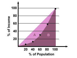 This Lorenz curve shows income distribution across different percentages of the population. Lorenz curves are commonly used to portray income distribution across the population.
Cartographic Animation
 A cartographic animation is a map that has moving aspects which show us what could happen under certain circumstances. In this case, the animation shows what would happen as the water came in from the coast and flooded the coastal area.
DRG
 The term DRG refers to digital raster graphics. Digital raster graphics come from the United States Geological Survey. These graphics are forms of topographical maps.
Subscribe to:
Posts (Atom)